Thursday Night Slight Chance Rain Showers then Patchy Fog
Lo 46°F
Hi 51°F
Lo 40°F
Dew Point
Liquid Precipitation
Wind Speed
Sun/Moon
Current:
48.2°F
Last Hour:
+0.3°F
High 12:28 AM:
48.2°F
Low 12:04 AM:
47.7°F
Record High:
75.6°F on
7-Sep-2023
Record Low:
-14.6°F on
3-Feb-2023
Wetbulb:
49.3°F
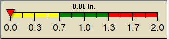
Rain Today
Today:
0.00 in
Yesterday:
0.00 in
Last 7 Days:
1.33 in
Apr Rain:
3.59 in
Apr to Date Avg:10
1.40 in
Apr to Date Diff from Avg:10
2.19 in
Apr Avg:
3.94 in
Diff from Avg:
0.35 in
Season:1
13.88 in
YTD Avg:11
8.34 in
YTD Diff from Avg:11
5.54 in
Last Rain Time/Date:
14-Apr-2024
at 12:20 PM
48 rain days in 2024
10 days in April
2 days since last rain
Current:
NNW
0.0 mph
1Hr Average:
0.4 mph
Wind Run:
0.06 miles
Wind Gust
Current:
0.0 mph
Today:
3.5 mph 12:08 AM
Month:
26.1 mph
13-Apr
Year:
33.0 mph
11-Mar
Record Gust:
33.0 mph
11-Mar-2024
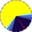
Sunlight:
13 h 26 m 20 s of Sunlight Yesterday 13 h 28 m 56 s of Sunlight Today
Which is 2 min 36 sec longer than yesterday 13 h 31 m 31 s of Sunlight Tomorrow (Noon ?>)(Midnight
1 Rain season: Jan 1st to Dec 31st.
2 Snow season July 1st to June 30th.
3 Snow manually measured usually around 7AM and 7PM.
6 Air Quality Index is provided by Minnesota Polution Control Agency and is updated hourly between the hours of 6AM and Midnight.
10 Historical average only to day 18 of just the month of April for this station since 2013.
11 Historical average rain this season to day 18 of April for this station since 2013.
NWS Weather Forecast -
Outlook Overnight & Thursday
Overnight
Patchy Fog
Lo 46°F
NWS forecast: Patchy fog and showers and thunderstorms before 3am, then patchy fog and a chance of showers and thunderstorms between 3am and 5am, then patchy fog and a slight chance of rain showers. Cloudy, with a low around 46. Southeast wind around 10 mph. Chance of precipitation is 90%. New rainfall amounts between a quarter and half of an inch possible. Local station forecast:Mostly cloudy and cooler, precipitation likely, windy with possible wind shift to the w, nw, or n.
Thursday
Chance Drizzle
Hi 51°F
NWS forecast: Areas of fog and a chance of rain showers before 9am, then a chance of rain showers and patchy fog between 9am and 11am, then a chance of drizzle and a chance of showers and thunderstorms between 11am and 1pm, then a chance of drizzle and a slight chance of showers and thunderstorms. Cloudy, with a high near 51. East wind around 8 mph. Chance of precipitation is 40%. New rainfall amounts between a tenth and quarter of an inch possible.
NWS Short Term Weather Forecast
Thursday Night Slight Chance Rain Showers then Patchy Fog
Friday
Mostly Cloudy then Slight Chance Rain Showers
Friday Night Chance Rain Showers
Saturday
Slight Chance Rain Showers then Partly Sunny
Saturday Night Partly Cloudy
Sunday
Mostly Sunny
Sunday Night Partly Cloudy
Lo 40°F
Hi 56°F
Lo 44°F
Hi 57°F
Lo 34°F
Hi 55°F
Lo 34°F
ajax-dashboard6.php - Version 6.95h - 20-Feb-2023 - Script by: Scott of BurnsvilleWeatherLIVE.com
Now supported by Saratoga-weather.org Download